Serving residents of Taupaki and the surrounding rural communityNext meeting: 7 December 2026, 7:30pm
← Back

The story of Taupaki

From tangata whenua and kauri logging to farming, the railway and today's rural community.

Pre-European · early 17th century onwards

History of Taupaki

Taupaki has a long history of connection with both Ngāti Whātua and Te Kawerau ā Maki, tangata whenua of the wider area.

For Ngāti Whātua, the Kaipara Harbour and its shores and hinterland have long been central to life and identity, reflected in the saying “Ko āna takutai, moana hoki ō Kaipara he ipu kai” — the harbour, its shores and hinterland are the food bowl. Ngāti Whātua o Kaipara encompasses the descendants of the ancestors of five marae across South Kaipara, including Whiti Te Rā Marae o Reweti, home to whānau of Te Taoū, a hapū of Ngāti Whātua with longstanding connections to the area.

Te Kawerau ā Maki, whose ancestor Maki migrated north with his hapū from the Kawhia–Taranaki region in the early 1600s, traditionally held lands from the Waitākere Ranges to the Kaipara Harbour. The foothills west and south-west of Taupaki were known as Ngā Rau Pou ā Maki (“the many posts of Maki”), while the great Waitākere forest was known as Te Wao nui ā Tiriwa.

The name Taupaki, meaning “the firmly bound peace”, reflects the boundary and peace settlement formed between Te Kawerau ā Maki and Ngāti Whātua in the early 18th century. The Kumeū River valley was also an important transport corridor and portage, known as Te Tōangaroa, linking the Kaipara and Waitematā harbours.

Treaty history

The history of Taupaki also needs to be understood in the context of the Crown’s acquisition of land across West Auckland. By 1854, the Crown had acquired most of the area, often without the proper involvement or consent of Te Kawerau ā Maki, and by the mid-20th century the iwi had become effectively landless.

Ngāti Whātua also experienced significant loss of land and other impacts from Crown actions, and both iwi have subsequently reached Treaty settlements with the Crown — Ngāti Whātua in 2013 and Te Kawerau ā Maki in 2014, with the latter settlement coming into force in 2015. These settlements included acknowledgements, apologies and redress, supporting the iwi to rebuild their cultural, social and economic wellbeing.

Today, both Te Kawerau ā Maki and Ngāti Whātua maintain strong connections to Taupaki and continue to exercise their mana as tangata whenua; Taupaki sits within the rohe identified by Ngāti Whātua’s Treaty settlement boundary, while Te Kawerau ā Maki are rebuilding their presence and connections across their traditional lands, including through the development of a new marae at Te Henga.
1870s–1881

Kauri, gum and the railway

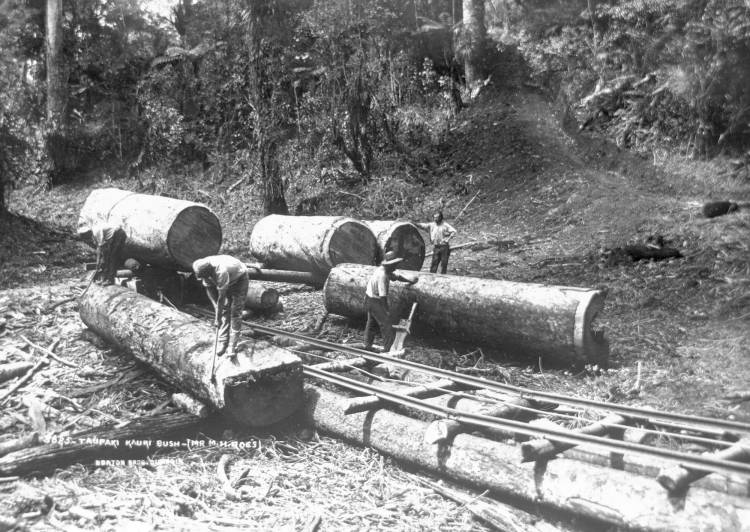
Kauri logging and gum digging drove the first major European activity. Access changed decisively when the North Auckland Line opened in 1881. Taupaki station opened on 18 July 1881, connecting timber and produce to Auckland markets.

The railway encouraged permanent settlement as workers stayed and the district shifted from logging towards farming.

Taupaki Kauri Bush, early 20th century

Taupaki Kauri Bush, early 20th century

1880s–1900s

From bush to pasture

Cleared land became pasture. Sheep farms were followed by increasingly viable dairy farming, supported by the railway and Taupaki’s rolling landscape.

Taupaki School opened in 1899 with 22 pupils and Miss Violet Johnson as its first teacher. The Presbyterian Church followed in 1907.

Early–mid 20th century

Taupaki Hall — the heart of the community

The hall was officially opened in February 1915 by Alex Harris MP. G. Crisp gifted the quarter-acre site and local residents contributed funds and labour, with local women including Mrs Sloan helping raise money.

The hall is a Category 2 heritage building with original timber lining. It has hosted meetings, dances, fundraisers, school gatherings, filming and community occasions for generations.

The railway era closes

Goods services ended in 1960, passenger services in 1967 and the station closed entirely in 1980. In 2025, more than 1,000 people signed a petition seeking restored rail services through Kumeū and Huapai, with a potential Taupaki station.

2000s–present

Taupaki today — a community at a crossroads

From 369 residents in 1936, Taupaki grew to 1,797 in the 2023 census, a 24% increase over ten years. The estimated 2025 population was around 1,870.

Taupaki remains a rural lifestyle community of open farmland, lifestyle blocks, school, hall and strong local connections, while facing pressure from Auckland’s growth boundary and surrounding development.

1881Railway station opened
1899Taupaki School founded
1915Taupaki Hall opened
1,797Residents in 2023

Help complete this history

The founding figures of the Association and its earliest chairpersons are not yet fully recorded. Photographs, documents and recollections are welcome.

Share information →

Notable connections

Barry Crump MBE (1935–1996)

The celebrated New Zealand author spent part of his childhood in Taupaki. His rural upbringing influenced his writing, including A Good Keen Man and Wild Pork and Watercress.

Miss Violet Johnson

Taupaki School’s first teacher in 1899, beginning with 22 pupils and laying the foundation for a school that celebrated 125 years in 2024.

Te Au o Te Whenua

The Te Kawerau ā Maki chief whose peacemaking with Ngāti Whātua established the boundary known as te taupaki.

Past Association chairpersons

Names, terms and contributions are still to be added from Association records and community knowledge.

Taupaki in regional context

Kumeū–Huapai

The nearby commercial centre, shaped by the railway, wine industry and substantial residential development.

Riverhead

A distinct rural village with historical connections to the Kaipara portage and early railway.

Waitākere Ranges

Te Wao nui ā Tiriwa forms Taupaki’s ecological and spiritual backdrop and is protected under the Waitākere Ranges Heritage Area Act.

Whenuapai

Major residential growth is increasing traffic and infrastructure pressure on routes through Taupaki.